Urban Barry
The Urban Barry properties is located in the Urban Township, in Quebec’s Eeyou Istchee James Bay region, approximately 700 kilometres north-northwest of Montreal, and 100 kilometres east of Lebel-sur-Quévillon’s municipality (figure 1). The Urban Barry property includes 1,372 map designated claims covering an area of approximately 741 km². The property is held by 50% by Osisko Mining. The property is contained in the central and eastern part of the Urban Barry greenstone belt, Abitibi Sub-Province, Archean Superior Province (figure 2). The property is confined within three NTS map sheets (32F, 32G and 32B).
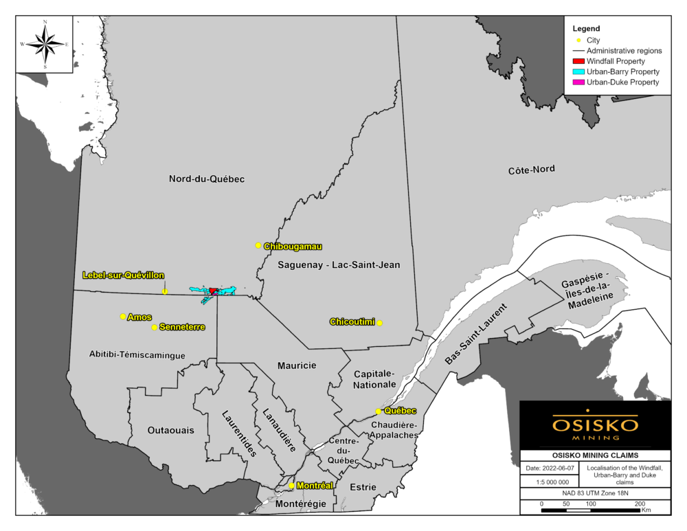
Figure 1: Map showing the location of the Urban Barry and Windfall properties.
Key Facts
Urban-Barry is located in Eeyou-Itschee James Bay Territory region of Quebec, Canada
Contains several gold occurrences such as the Fox SW, Black Dog and Nubar showings
Same Geological setting and rock age as Windfall
Covers the majority of the Bank Fault (Mazères)
LATEST NEWS — URBAN BARRY
Project Description
Geology
The Urban-Barry Greenstone Belt
The Urban-Barry greenstone belt is part of the Abitibi Subprovince (figure 2). The belt is an east-west trending belt that is 135 kilometres long by 4 to 20 kilometres wide. The belt is dominated by mixed mafic to felsic volcanic rocks with lesser fine-grained clastic sedimentary sequences (figure 3). This greenstone belt was deformed during the 2.71 to 2.66 Ga Kenoran orogen (Card, 1990). The rocks generally record greenschist grade metamorphism, but locally reach amphibolite facies within corridors of intense deformation and proximal to large pluton contacts (Joly, 1990). The regional metamorphic temperature-pressure gradient generally increases eastward towards the Grenville Front.
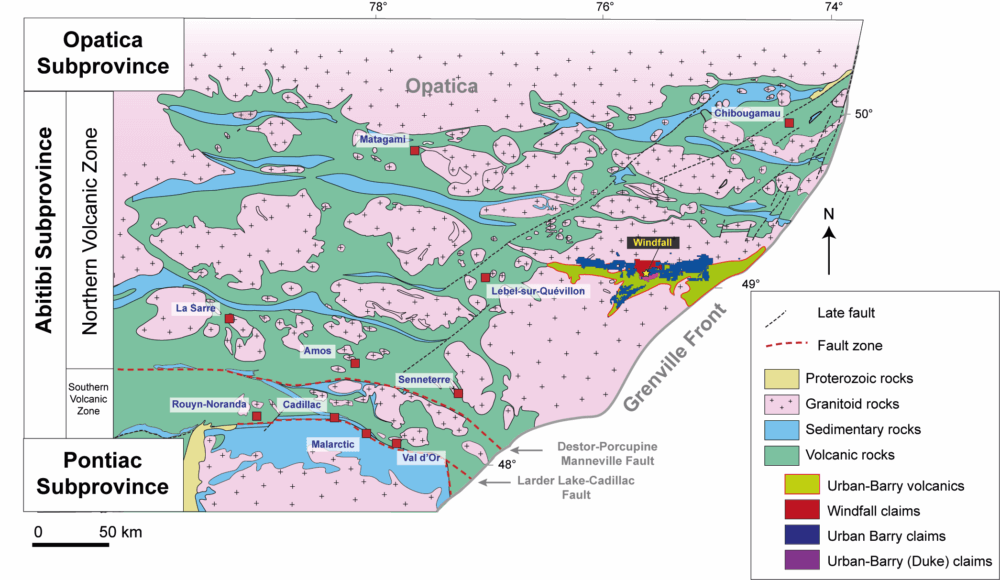
Figure 2: Simplified regional geology map showing the location of the Urban Barry greenstone belt.
The greenstone belt is crosscut by several east-trending and east-northeast trending shear zones that delineate major structural domains: 1) the Urban Deformation zone, a major sub-vertical, east-west-trending and dextral ductile shear zone extending along the northern margin of the greenstone belt (Bandyayera et al. 2002); and 2) the central portion of the Urban Barry belt consists of a moderate strain fault-related folds style. The main foliation in this domain is oriented east-northeast and contains the Urban Syncline. The central portion of the belt is transected by the east-northeast-trending Milner, Masères, and the Barry ductile shear zones.
The belt is divided into five rock formations that are constrained from 2791 to 2707 Ma (Rhéaume and Bandyayera, 2006):
- The Fecteau formation (2791 Ma) is the oldest and is located in the southeast limit of the belt. It mainly consists of tholeiitic mafic to felsic volcanics including minor graphitic sedimentary units (Bandyayera et al. 2004).
- The Lacroix formation (no age) mainly consists of komatiites and mafic volcanics, and minor calc-alkaline to transitional andesites.
- The Chanceux formation (2727 Ma), mainly consists of tholeiitic basalt, gabbros, and thin beds of rhyodacitic or rhyolitic tuffs interlayered with greywackes and graphitic argillite (Bandyayera et al. 2004).
- The Macho formation (2717 Ma) is located in the central part of the belt, mainly consists of basalt, andesite and basaltic andesite with comagmatic gabbroic sills (Bandyayera et al. 2002, 2004). The Macho Formation includes the Windfall and Rouleau members. A series of quartz and/or feldspar porphyry dikes cut across volcanic rocks of the Macho Formation, including rocks of the Windfall Member. The dikes have been dated at 2697 ±0.6 Ma at the Barry gold deposit (Kitney et al. 2011), which is located approximately 10 km southwest of the Windfall deposit, and at 2697 ±0.9 Ma at the Windfall deposit (Davis 2016, unpublished),.
- The Urban formation (2714 to 2707 Ma) is the youngest formation and consists of glomeroporphyritic tholeiitic basalt with minor synvolcanic gabbro inferred to be coeval with the Obatogamau Formation in Chibougamau. It equally includes felsic volcanics and sediments (Bandyayera et al. 2002).
Osisko mining is currently the largest stakeholder in the Urban-Barry greenstone belt with over 40 % of the land staked.
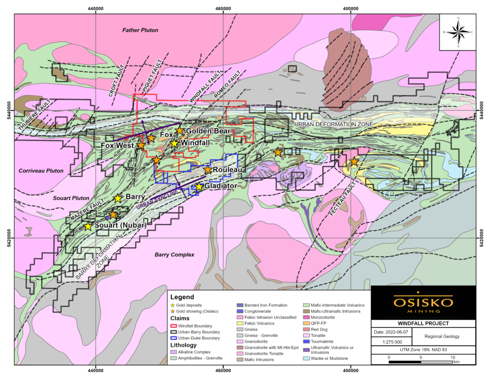
Figure 3: Geological map of the Urban Barry greenstone belt showing the geology, structures, and the location of various gold deposits and showings.
Gold Mineralization
Early-stage exploration projects in the Urban Barry greenstone belt
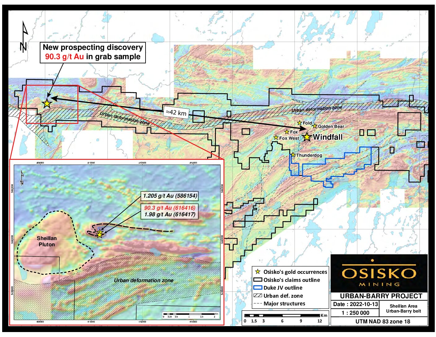
Other than the Windfall deposit, there are several other significant occurrences of gold mineralization in the Urban Barry greenstone belt. Within Osisko claim boundaries the most notable gold occurrences are 1) the Fox trend, and 2) the Black Dog trend. These are both discussed in further detail below.
Fox trend
The Fox trend is located 4 kilometers west of the Windfall deposit (figure 3). The area is characterized by a sequence of mixed mafic to felsic volcanics, gabbro sills, and graphitic sediments that are cross-cut by several generations of calc-alkaline quartz-feldspar porphyry dikes, similar to those found in the Windfall deposit. The rocks are overprinted by the Milner deformation zone which is a regional scale east-northeast trending deformation zone that is parallel to the structure that hosts the Windfall deposit (figure 3). Previous work in the area includes geological mapping, several geophysical surveys including magnetic, electromagnetic and induced polarization surveys, till and soil sampling as well as several diamond drillings programs.
Gold mineralization along the Fox trend is hosted in deformation zones that are strongly altered to a pervasive silica-sericite-carbonate-pyrite alteration that are cross-cut by stockworks of dark grey quartz-pyrite veinlets. Gold mineralization has been defined along trend of the Milner deformation zone for 2.5 kilometres and is still open and poorly tested along strike. The two main zones are the Fox and Fox West (“Fox W”) zones (figure 4). The most significant mineralization at Fox was from drillhole OSX-W-16-717 which intersected 3.22 g/t Au over 11.6 m (see Osisko press release – August 29, 2016), at Fox from drillhole OSK-U-16-734 which intersected 27.6 g/t Au over 3.1 m (see Osisko press release – November 23, 2016), and at Fox W from drillhole OSK-UB-19-132 intersected 16.7 g/t Au over 2.8 m (see Osisko press release – June 6, 2019).
Mineral Resource Estimate
There is no Mineral Resource Estimation on the Urban Barry project at this point.
Deposit Type
The gold showings along the Fox trend share many similarities with the Windfall deposit. The gold is hosted in the same volcanic sequence, is associated with the same pre- and post-mineral quartz-feldspar porphyry intrusions and is associated with an east-northeast trending deformation zone. The gold found within the Fox trend is interpreted to be synchronous with the gold event that formed the Windfall deposit.
Technical Reports
Maps and Sections
General Maps
Figure 1: Map showing the location of the Urban Barry and Windfall properties.
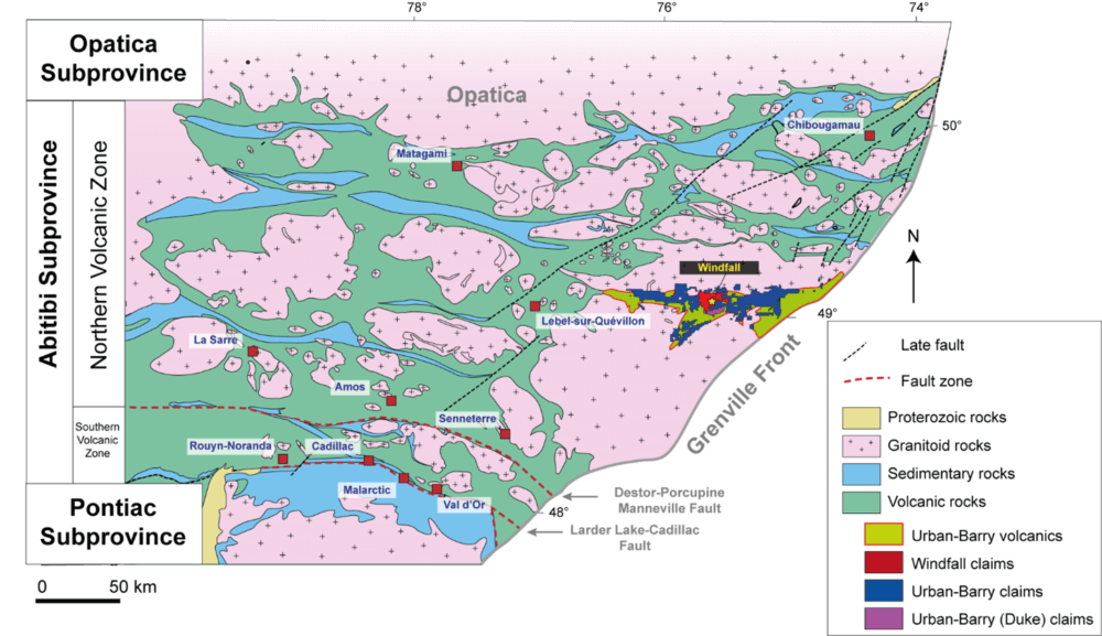
Figure 2: Simplified regional geology map showing the location of the Urban Barry greenstone belt.
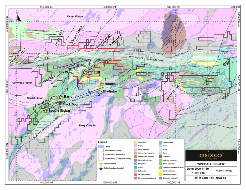
Figure 3: Geological map of the Urban Barry greenstone belt showing the geology, structures, and the location of various gold deposits and showings.
Press Release Maps
Drill Results

© 2025 OSISKO MINING | LEGAL & PRIVACY